Evolving Infrastructure Through AI, Data, and Digital Intelligence

We combine computer vision, Edge AI, and real-time analytics to automate pavement evaluation and road condition monitoring. Beyond inspection, our ecosystem integrates financial intelligence, predictive modeling, traffic consulting, environmental impact assessment, and digital twin simulations of road networks. From data capture to interactive BI dashboards, we empower our customers to plan, simulate, and optimize infrastructure with precision and sustainability.

Explore Our Technology
Logotipo Just in Flow

Jump from the ordinary | Hack your flow zone | Boost your creativity

AI-Powered Pavement Inspection System

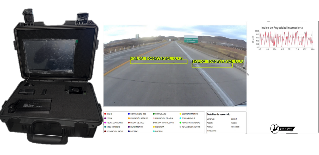
Our AI-powered visual inspection system captures and analyzes pavement conditions in real time, detecting cracks, potholes, and surface wear with high precision. Trained with our own proprietary datasets, the model accurately identifies up to 18 types of pavement distresses, providing a comprehensive understanding of road performance.

It delivers actionable, data-driven insights faster than traditional methods, helping engineers and authorities make informed decisions, optimize maintenance plans, and extend the lifespan of road infrastructure.

On-Board Intelligent Pavement Assessment

Designed for seamless on-board integration, our portable Edge AI device adapts to any vehicle, enabling real-time visual inspection of road conditions.

Equipped with high-precision sensors and GPS, it continuously evaluates the International Roughness Index (IRI) and spatial data to generate accurate, location-based pavement assessments. This unified system delivers actionable insights directly from the field, enhancing maintenance efficiency and infrastructure planning.

Video detección

AI-Based Traffic Detection and Analytics

Using aerial and fixed camera inputs, our system automatically detects, classifies, and tracks vehicles in real time. It provides complete traffic analytics, including speed, flow direction, lane usage, and occupancy rates, enabling accurate studies of mobility and congestion.

The AI model operates fully autonomously and adapts to diverse road environments, supporting infrastructure planning and smart city management.

AI-Based Traffic Heatmaps and Flow Analytics

Our system generates dynamic traffic heatmaps that visualize vehicle density, speed variations, and flow direction in real time. By combining visual data with AI-based analytics, it identifies congestion patterns, lane usage, and mobility trends across corridors.

This allows engineers and city planners to anticipate bottlenecks, optimize road performance, and design data-driven mobility strategies

Digital Twin Models for Traffic and Mobility Simulation

Our digital twin models recreate real-world traffic systems in virtual environments to analyze and predict mobility dynamics. Using PTV Vissim and AI-based simulation, we assess traffic flow, congestion patterns, queue lengths, and vehicle interactions across complex road networks.

These models enable authorities and consultants to test infrastructure scenarios, evaluate operational strategies, and optimize design and mobility performance before implementation.

BI Dashboards for Pavement Performance Analysis

All the information captured by our AI systems is processed and displayed through interactive BI dashboards. These dashboards allow users to visualize road conditions, defect distribution, IRI values, and budget indicators in real time.

Each visualization is designed to simplify technical analysis, offering a clear overview of infrastructure performance. Users can explore, filter, and export reports, turning raw data into actionable insights for efficient maintenance and strategic planning.